Details of our proposals
- widening the pavements on King Henry's Walk would help create an improved public space
- more trees, planting and seating would make the street a greener and more pleasant place in which to spend time
- there is too much traffic for children to travel safely to local schools
- it is difficult to cross King Henry's Walk in places
- we need to support local businesses with their specific access and loading requirements
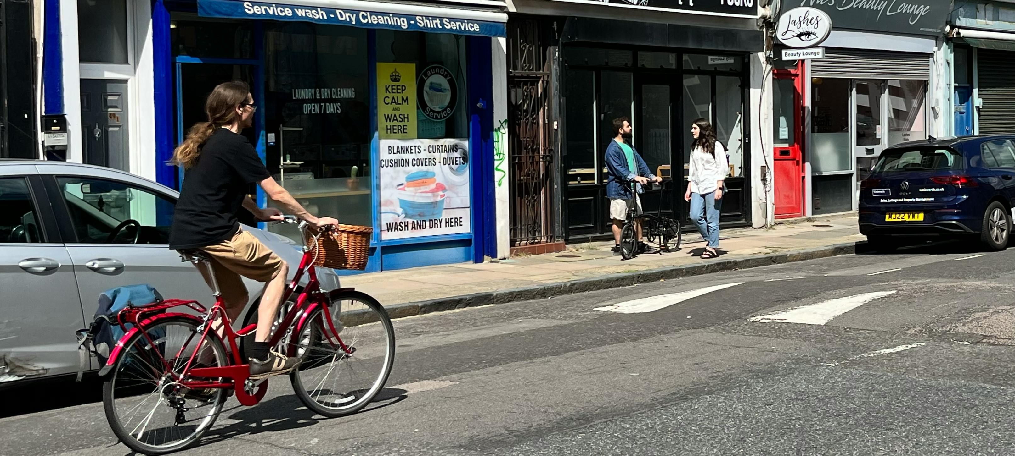
- wider pavements with new planting, trees, benches and cycle parking. This will require around 20 parking spaces to be removed. There is alternative parking available on nearby streets including Queen Margaret's Grove, St Jude Street and Mildmay Grove North
- a new public space with seating and planting at the junction of Queen Margaret's Grove and King Henry's Walk, created by closing this junction to motor vehicles
- new continuous crossings at Queen Margaret’s Grove and St Jude Street
- a dedicated loading bay for business deliveries
- you are concerned that air pollution is high and the road feels dangerous outside Newington Green Primary School
- the entrance to the school should be quieter, safer and more child-friendly
- there should be wider pavements with new greenery, trees and cycle parking on Mildmay Road
- support Newington Green Primary School to relocate their main entrance to Auriga Mews
- introduce wider pavements, new planting and trees, cycle parking and seating on Mildmay Road at the junction of Wolsey Road and Auriga Mews. This will require around 8 parking spaces to be removed around the junction
- create a School Street zone on Mildmay Road, Wolsey Road and Auriga Mews in the vicinity of the proposed new entrance, to create a safer space for walking, wheeling and cycling outside the school entrance at peak school travel times. In this zone, motor vehicles will be prohibited at school drop-off and pick-up times (except resident permit holders living in the zone)
- St Jude Street is a narrow street which can become congested with vehicles and people walking and cycling at peak times
- you are concerned about air pollution and road danger close to the local schools
- the road should be made safer for children travelling to school with the introduction of a School Street
- create a School Street zone covering St Jude Street and the small section of Kingsbury Road north of the railway bridge, to create a safer space for walking, wheeling and cycling near the two schools' entrances. In this zone, motor vehicles will be prohibited at school drop-off and pick-up times (except resident permit holders living in the zone)
- remove the existing width restriction on St Jude Street near Boleyn Road and introduce a new traffic filter in its place using planters or bollards (as shown in our Proposal 4: New traffic filtering proposals)
- there is wide support for reducing through-traffic in this area, to improve air quality and enable families and children to walk, wheel and cycle to school on local streets
- when accessing the area by vehicle, more people do so from the west side (from Newington Green and Mildmay Park) rather than the east side (from the A10 and Crossway)
- one traffic filter on Mildmay Road and one on King Henry's Walk, prohibiting traffic in both directions (except exempt vehicles)
- a one-way traffic filter on Boleyn Road just south of the junction with Pellerin Road, to allow general traffic to drive through northbound (as at present) but to allow only buses and exempt vehicles to drive southbound through the filter
- one traffic filter with planters or bollards to prevent through traffic on Queen Margaret's Grove, and a similar filter on St Jude Street. Installing these physical filters will enable the creation of traffic-free public space on Queen Margaret's Grove and a new School Street zone on St Jude Street
- to introduce these measures will require around 8 parking spaces to be removed
- the space is heavily dominated by traffic
- it feels unsafe to use the zebra crossings between the high street and the Green due to fast traffic with poor visibility and many vehicles failing to stop
- it is difficult and unsafe to cycle around Newington Green, including reaching the protected cycle lanes further north on Green Lanes
- safety improvements at nine existing zebra crossings, with raised tables to slow down vehicles and wider pavements to shorten crossing distances. At the zebra crossing outside 56 Newington Green near the café on the Green, this will require the inset parking space to be slightly reduced in length. We will also look to increase the dedicated loading-only hours within this parking bay, so that the many businesses in the area can more reliably service their premises
- a safe route for cycling between Mildmay Road and Ferntower Road, separated from vehicles and the pavement, and with safe crossings of the main road. This supports our aim for people to be able to safely cycle between the major cycle routes Cycleway 1 and Green Lanes
- new planting to create a greener space, with new space for hospitality businesses to continue to have tables and chairs at Ferntower Road
- Boleyn Road is unsafe to cycle on due to high levels of traffic and parked cars
- the road is difficult to cross for people walking and wheeling between the housing estates on each side, with busy traffic and no crossing places between Wordsworth Road and Crossway
- it is dangerous for people cycling to turn right from Boleyn Road to Wordsworth Road on Cycleway 1, due to busy traffic
- the 236 bus can be delayed due to the level of traffic and the parked cars on both sides of the road
- introduce a northbound protected cycle lane on Boleyn Road between Crossway and Wordsworth Road with a new northbound bus stop island and cycle bypass, to protect people cycling from traffic danger. These proposals will require the removal of 22 Islington residential parking spaces and relocation of three electric vehicle charging points locally; and the removal of four Hackney residential and ten Hackney shared-use parking spaces. The reduction of parking spaces will also help reduce congestion for the 236 bus
- create a new zebra crossing near Shellgrove Road to connect walking routes through the estates on both sides of Boleyn Road
- move the existing zebra crossing closer to the junction with Wordsworth Road, with a new cycle crossing parallel to the zebra crossing
- introduce a one-way traffic filter on Boleyn Road just south of the junction with Pellerin Road (as also shown on our 'Proposal 4: New traffic filtering') which would allow traffic to drive northbound as usual, but southbound only buses and exempt vehicles would be allowed to pass through the filter
- there are physical barriers to walking and wheeling around the Mayville Estate, such as narrow gates and uneven pavements
- the estate would benefit from new greenery on existing 'grey' spaces
- many people want to be able to cycle between Boleyn Road and King Henry Street, but this is difficult as there is no dropped kerb for cyclists to use
- improved, greener public space outside Conrad House, including raising the car park up to pavement level to create new walking space with planting, relocating the waste and recycling bins, and providing cycle access between Boleyn Road and King Henry Street. This will require eight estate car parking spaces to be removed
- a more accessible route for walking and wheeling past Waller, Skelton, Emerson and Bronte Houses, by reducing the length of the existing speed humps on the estate road to provide spaces for people to comfortably pass through with buggies and wheelchairs, and by increasing the spacing of the chicane barrier on the path near Matthias Road. This would also make it easier for people walking and wheeling between Mildmay Road and Matthias Road to reach the proposed new school entrance on Auriga Mews (shown in our 'Proposal 2: Child-friendly street improvements outside Newington Green Primary School')
- new planting and seating on the wide pavement on Arundel Grove by King Henry Street, to create a greener space and a place for people to sit and rest
- introduce a loading bay on Mildmay Grove North by the junction of Mildmay Park to provide loading access for the local shop
- repair pavements at several locations to make Mildmay Park smoother and more accessible to walk and wheel
Proposal 1: New public space on King Henry’s Walk
King Henry's Walk is at the centre of the Mildmay community, with local businesses, two primary schools, places of worship and play facilities. We want to support this community hub and help make it an attractive space for local people, schoolchildren, businesses and their customers.
In our engagement with local people so far you have told us that:
We are proposing to create:
 King Henry's Walk proposed public space improvements
Proposal 2: Child-friendly street improvements outside Newington Green Primary School
Newington Green Primary School is a focal point of the Mildmay community. Currently, pupils enter the school at Matthias Road which has narrow pavements and busy traffic.
In our engagement so far you have told us that:
We are therefore proposing to:
 Mildmay Road-Wolsey Road proposed public space improvements
Download a larger (PDF) version of this drawing
 Mildmay Road proposed School Street
Proposal 3: School Street on St Jude Street to benefit two primary schools
St Jude Street provides access to the Kingsbury Road bridge, St Jude and St Paul's Primary School, and the Children's House School. The street is adjacent to the popular St Jude Street Garden, and is on the route of Cycleway 1 between Tottenham and the City of London.
There is an existing School Street zone nearby outside St Jude and St Paul’s Primary School, covering Kingsbury Road, Kingsbury Terrace and Burder Close.
In our engagement so far, you have told us that:
We are therefore proposing to:
 St Jude Street proposed School Street and traffic filter
Proposal 4: New traffic filters to create quieter, safer streets
We want to create safer, friendlier streets with lower traffic volumes and speeds across Mildmay. Many residential roads provide appealing cut-through routes for motor traffic. Reducing traffic on local streets will make them quieter and calmer, with cleaner air, and enable children and local people to feel safe and confident to walk, wheel and cycle more local journeys, including to schools.
In our engagement so far, you have told us that:
We are proposing to introduce five traffic filters in local streets in the Mildmay Liveable Neighbourhood, including:
 Our proposed traffic filter arrangement for the Mildmay Liveable Neighbourhood
You can download our scheme information sheet for information about how motor vehicles would access each street in the scheme area, and about Islington traffic filters and exemptions policies.
Proposal 5: Walking and cycling improvements around Newington Green
Newington Green is a major destination in the area, with people walking, wheeling and cycling to access the green space, cafe and playground, as well as the range of businesses in the area and Newington Green Primary School. The A105 gyratory around the Green is a busy main road environment.
In our engagement so far, you have told us that:
We are proposing to make walking and cycling safer by introducing:
 Artist's impression of the proposed improvements at Newington Green by Ferntower Road


 Newington Green proposed walking and cycling improvements (close up of west side)
 Newington Green proposed walking and cycling improvements (close up of east side)
 Newington Green proposed zebra crossing improvements - west side of the Green
Proposal 6: Walking and cycling improvements on Boleyn Road
Boleyn Road is a busy road which forms part of Cycleway 1, a TfL cycle route used by large numbers of people cycling every day. Boleyn Road also hosts the 236 bus route, which is a vital community asset enabling access to places such as Broadway Market, Homerton Hospital, Highbury Barn, and Finsbury Park station. The road forms a boundary between the boroughs of Islington and Hackney, with the Mayville and Shellgrove estates fronting onto the street.
In our engagement so far, you have told us that:
We are therefore proposing to:
 Boleyn Road walking and cycling improvements: northern section including new parallel crossing into Wordsworth Road
 Boleyn Road walking and cycling improvements: central section including new zebra crossing by Shellgrove Road
 Boleyn Road walking and cycling improvements: southern section
Download a larger (PDF) version of the Boleyn Road / Wordsworth Road parallel crossing drawing
Proposal 7: Improvements for walking and cycling on the Mayville Estate
The Mayville Estate is located within the Mildmay Liveable Neighbourhood project area. Many children attending local schools live on the estate, and the number of households with access to a car is lower than across the wider area.
During our engagement so far, you have told us that:
We want to make it easier and more accessible for residents and visitors to get around the Mayville Estate by walking, wheeling and cycling. We are therefore proposing to create:
 Conrad House proposed public space, walking and cycling improvements Download a larger (PDF) version of this drawing
 Mayville Estate walking and wheeling improvements
 Arundel Grove proposed greening
Proposal 8: New business loading and accessibility improvements on Mildmay Park
Mildmay Park, located along the west side of the Mildmay Liveable Neighbourhood, hosts local businesses and the Mildmay Library. The route 141 bus connects Mildmay Park with key destinations further afield such as Green Lanes, Old Street and London Bridge.
In our engagement so far, you have told us that Mildmay Park has multiple areas where the pavements are uneven, making it difficult to walk and wheel for people whose mobility is impaired. The grocery shop on the corner of Mildmay Park and Mildmay Grove North has highlighted that it is currently difficult for them to receive deliveries as there is no dedicated loading space.
We are proposing to:
 Mildmay Grove North proposed loading bay